


Pats Peak Trail Map & Piste Map
Pats Peak Paper Trail Maps
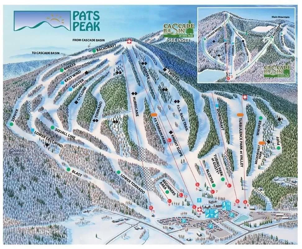
How to Read the Pats Peak Trail Map
Trail Difficulty Colors
- • Green: Beginner-friendly runs for new skiers
- • Blue: Intermediate trails with moderate challenge
- • Black: Advanced runs requiring strong skills
- • Double Black: Expert-only terrain with high difficulty
Note: North American resorts use Green for beginner and Blue for intermediate runs
Map Symbols
🚡 Chairlifts: Main mountain access
🔄 Gondolas: Enclosed cabin transport
🎿 Ski Runs: Marked trails with difficulty ratings
🏠 Facilities: Lodges, restaurants, and services
💡 Pro Tip: Start with green runs to warm up
Trails
Total Runs
28
Total Area
115 ac
46.5 ha
📱 Complete Pats Peak Mountain Intelligence
Pats Peak Trail Map FAQ - Complete Ski Runs Guide
How many ski runs does Pats Peak have?
Pats Peak features 28 ski runs covering 115 acres (46.5 hectares) of terrain. The Pats Peak trail map shows runs for all skill levels from beginner green runs to expert black diamond trails.
Can I download the Pats Peak trail map?
Yes! The Pats Peak trail map is available for download as a PDF file. Look for the download button on the trail map image above. This Pats Peak piste map can be saved to your phone or printed for easy reference while skiing.
What do the colors on the Pats Peak trail map mean?
The Pats Peak trail map uses standard ski run difficulty ratings: Green for beginner runs, Blue for intermediate, Black for advanced, and Black for expert terrain. This Pats Peak ski map color coding helps you choose appropriate trails for your skill level.
Where are the best beginner runs at Pats Peak?
Beginner skiers should look for green runs on the Pats Peak trail map, typically located near the base area and served by beginner-friendly lifts. The Pats Peak ski map shows these gentle slopes perfect for learning and building confidence.
How do I find the fastest way down the mountain at Pats Peak?
Use the Pats Peak trail map to identify blue and red runs that connect directly to the base area. Look for trails marked as “direct routes” or “main runs” on the Pats Peak piste map. These typically offer the most efficient descent from the summit.
Are there any hidden trails not shown on the Pats Peak trail map?
The Pats Peak trail map shows all official marked ski runs and maintained trails. However, some advanced skiers may discover unofficial routes between marked trails. Always check the Pats Peakski map for current trail status and closures before exploring.
How often is the Pats Peak trail map updated?
The Pats Peak trail map is updated seasonally to reflect any new trails, lift changes, or facility additions. For real-time trail conditions and closures, check the current snow report alongside the Pats Peak piste map.
Can I use the Pats Peak trail map on my mobile device?
Absolutely! The Pats Peak trail map is fully mobile-optimized. You can view the interactive Pats Peakski map on your smartphone or tablet, and download the PDF version for offline use. This makes thePats Peak trail map perfect for on-mountain navigation.
Resort Stats
Elevation
Base
210m
Summit
445m
Annual Snowfall
2.03m
Season
2025 - 2026
12/13/2025 - 4/13/2026
Trail Coverage
28 Runs
115 ac (46.5 ha)
Top Global Snowfall
Next 5 days
Latest News

Germany's Zugspitze Ski Lift Demolished as Glacier Disappears Beneath It
Mar 22, 2026

Two Skiers Killed in Val Ridanna Avalanche as 25 Tourers Caught on Same Slope
Mar 22, 2026

Tomorrowland Winter 2026 Returns to Alpe d'Huez With New Stages and 100+ Artists
Mar 21, 2026

Kelly Canyon to Extend Snowmaking to Top of Goldrush Lift Ahead of 2026-27 Season
Mar 21, 2026

Aspen Highlands Files 10-Year Plan With New Gondola and Lift Upgrades to Tackle Congestion
Mar 21, 2026