


Note: North American resorts use Green for beginner and Blue for intermediate runs
🚡 Chairlifts: Main mountain access
🔄 Gondolas: Enclosed cabin transport
🎿 Ski Runs: Marked trails with difficulty ratings
🏠 Facilities: Lodges, restaurants, and services
💡 Pro Tip: Start with green runs to warm up
Total Runs
155
Total Area
1509 ac
610.7 ha
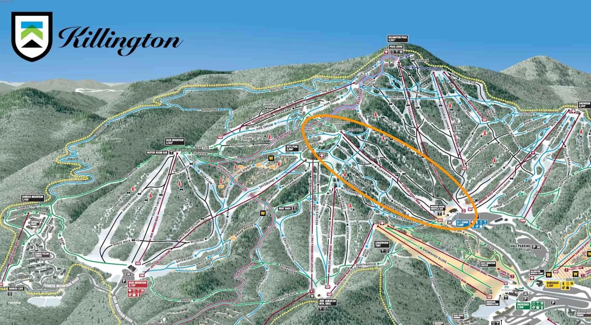
Killington features 155 ski runs covering 1509 acres (610.7 hectares) of terrain. The Killington trail map shows runs for all skill levels from beginner green runs to expert black diamond trails.
Yes! The Killington trail map is available for download as a PDF file. Look for the download button on the trail map image above. This Killington piste map can be saved to your phone or printed for easy reference while skiing.
The Killington trail map uses standard ski run difficulty ratings: Green for beginner runs, Blue for intermediate, Black for advanced, and Black for expert terrain. This Killington ski map color coding helps you choose appropriate trails for your skill level.
Beginner skiers should look for green runs on the Killington trail map, typically located near the base area and served by beginner-friendly lifts. The Killington ski map shows these gentle slopes perfect for learning and building confidence.
Use the Killington trail map to identify blue and red runs that connect directly to the base area. Look for trails marked as “direct routes” or “main runs” on the Killington piste map. These typically offer the most efficient descent from the summit.
The Killington trail map shows all official marked ski runs and maintained trails. However, some advanced skiers may discover unofficial routes between marked trails. Always check the Killingtonski map for current trail status and closures before exploring.
The Killington trail map is updated seasonally to reflect any new trails, lift changes, or facility additions. For real-time trail conditions and closures, check the current snow report alongside the Killington piste map.
Absolutely! The Killington trail map is fully mobile-optimized. You can view the interactive Killingtonski map on your smartphone or tablet, and download the PDF version for offline use. This makes theKillington trail map perfect for on-mountain navigation.
Elevation
Base
355m
Summit
1293m
Annual Snowfall
6.35m
Season
2025 - 2026
11/22/2025 - 5/25/2026
Trail Coverage
155 Runs
1509 ac (610.7 ha)

Apr 4, 2026

Apr 3, 2026
Apr 3, 2026

Apr 3, 2026

Apr 3, 2026