


Hotham Trail Map & Piste Map
Hotham Paper Trail Maps
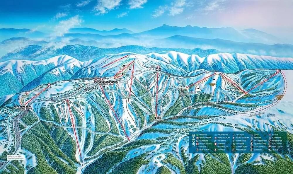
How to Read the Hotham Trail Map
Trail Difficulty Colors
- • Green: Beginner-friendly runs for new skiers
- • Blue: Intermediate trails with moderate challenge
- • Black: Advanced runs requiring strong skills
- • Double Black: Expert-only terrain with high difficulty
Note: North American resorts use Green for beginner and Blue for intermediate runs
Map Symbols
🚡 Chairlifts: Main mountain access
🔄 Gondolas: Enclosed cabin transport
🎿 Ski Runs: Marked trails with difficulty ratings
🏠 Facilities: Lodges, restaurants, and services
💡 Pro Tip: Start with green runs to warm up
Trails
Total Runs
72
Total Area
791 ac
320.1 ha
📱 Complete Hotham Mountain Intelligence
Hotham Trail Map FAQ - Complete Ski Runs Guide
How many ski runs does Hotham have?
Hotham features 72 ski runs covering 791 acres (320.1 hectares) of terrain. The Hotham trail map shows runs for all skill levels from beginner green runs to expert black diamond trails.
Can I download the Hotham trail map?
Yes! The Hotham trail map is available for download as a PDF file. Look for the download button on the trail map image above. This Hotham piste map can be saved to your phone or printed for easy reference while skiing.
What do the colors on the Hotham trail map mean?
The Hotham trail map uses standard ski run difficulty ratings: Green for beginner runs, Blue for intermediate, Black for advanced, and Black for expert terrain. This Hotham ski map color coding helps you choose appropriate trails for your skill level.
Where are the best beginner runs at Hotham?
Beginner skiers should look for green runs on the Hotham trail map, typically located near the base area and served by beginner-friendly lifts. The Hotham ski map shows these gentle slopes perfect for learning and building confidence.
How do I find the fastest way down the mountain at Hotham?
Use the Hotham trail map to identify blue and red runs that connect directly to the base area. Look for trails marked as “direct routes” or “main runs” on the Hotham piste map. These typically offer the most efficient descent from the summit.
Are there any hidden trails not shown on the Hotham trail map?
The Hotham trail map shows all official marked ski runs and maintained trails. However, some advanced skiers may discover unofficial routes between marked trails. Always check the Hothamski map for current trail status and closures before exploring.
How often is the Hotham trail map updated?
The Hotham trail map is updated seasonally to reflect any new trails, lift changes, or facility additions. For real-time trail conditions and closures, check the current snow report alongside the Hotham piste map.
Can I use the Hotham trail map on my mobile device?
Absolutely! The Hotham trail map is fully mobile-optimized. You can view the interactive Hothamski map on your smartphone or tablet, and download the PDF version for offline use. This makes theHotham trail map perfect for on-mountain navigation.
Resort Stats
Elevation
Base
1450m
Summit
1861m
Annual Snowfall
3m
Season
2026
6/6/2026 - 10/4/2026
Trail Coverage
72 Runs
791 ac (320.1 ha)
Latest News
European Alps Snow Report: Multiple Resorts Record Over 1 Metre in 24 Hours — March 2026
Mar 15, 2026

Skiing the Sella Ronda Green Route: A First-Timer's Guide to the Dolomites' Famous Circuit
Mar 15, 2026
Pacific Northwest Ski Resorts Just Got Buried — March 2026 Snow Report
Mar 15, 2026
Rockslide Closes Whistler Peak Zone: What Actually Happened
Mar 14, 2026

Val Gardena Day 2: 25cm Overnight and Why the Dolomites Keep Delivering
Mar 13, 2026